Surveying & Geomatics · 2026
GNSS Topographic Survey – Lot 3 Base Plan
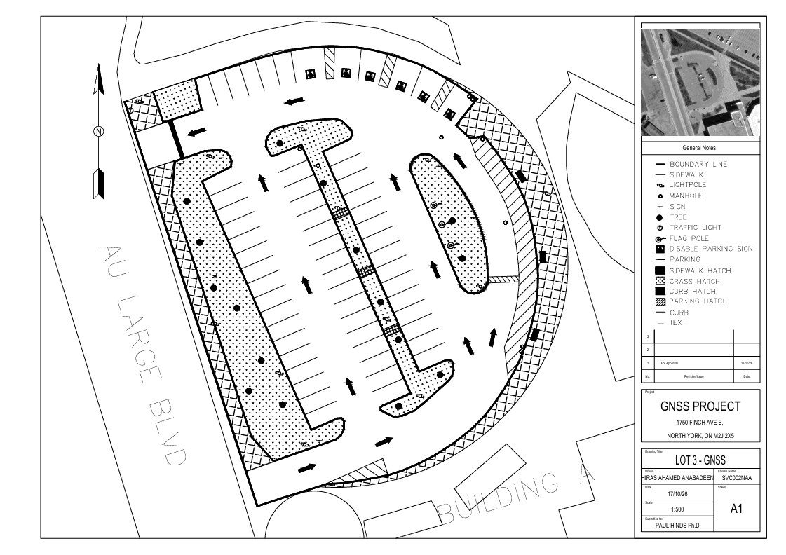
RTK GNSS topographic survey of Lot 3 at Seneca Polytechnic’s Newnham Campus. I collected 169 coded points and drafted them into a 1:500 base plan in Civil 3D and AutoCAD.
- My role
- Field Surveyor & Drafter
- Drawing scale
- 1:500
What I worked on
This project was a topographic survey of Lot 3 at Seneca Polytechnic’s Newnham Campus (1750 Finch Ave E, North York). The lot is roughly semicircular. Au Large Boulevard borders it on the west and Building A on the south. Traffic circulates one way around a curved outer drive, and three long rows of parking sit inside it. Working as part of a two-person crew, I located and recorded the lot’s features with RTK GNSS equipment. The 169 coded points covered: the lot boundary, curbs and sidewalks grass islands, trees, light poles and the flag pole manholes, signs and traffic signals accessible parking stalls and hatched no-parking zones I imported the point data into Civil 3D, generated linework from the feature codes, and produced the final plotted base plan at 1:500 in AutoCAD.
Project brief
Locate and record all features of the assigned parking lot subsection using RTK GNSS. Then produce an accurate 1:500 base plan with a legend, title block and north arrow. This was coursework for SVC002 – Surveying.
Technical work
Collected 169 RTK rover shots with a pole-mounted Sokkia GRX3 receiver and data collector, working off a base station about 314 m away.
Got fixed RTK solutions under good satellite geometry (PDOP 1.048), with sample shot precision of 4 mm horizontal and 6 mm vertical.
Used field feature codes (BC/CL/EC curve control, B/CLS start and close) so linework could be built automatically.
Referenced coordinates to NAD83 / UTM Zone 17N, using ground coordinates in metres.
Organized the points file and code table in Excel, then imported the points into Civil 3D to generate curbs, islands and boundary linework.
Digitized features outside the survey boundary from a reference map in ArcGIS Pro.
Drafted the final 1:500 plan with hatching (grass, sidewalk, curb, no-parking), a symbol legend, an aerial key map, a revision block and a title block.
Recorded offset shots at tree trunks and pole centres where the receiver couldn’t occupy the point directly, or where tree canopy blocked the signal.
Project drawing PDF
GNSS-SURVEY-LOT3.pdf · 0.36 MB